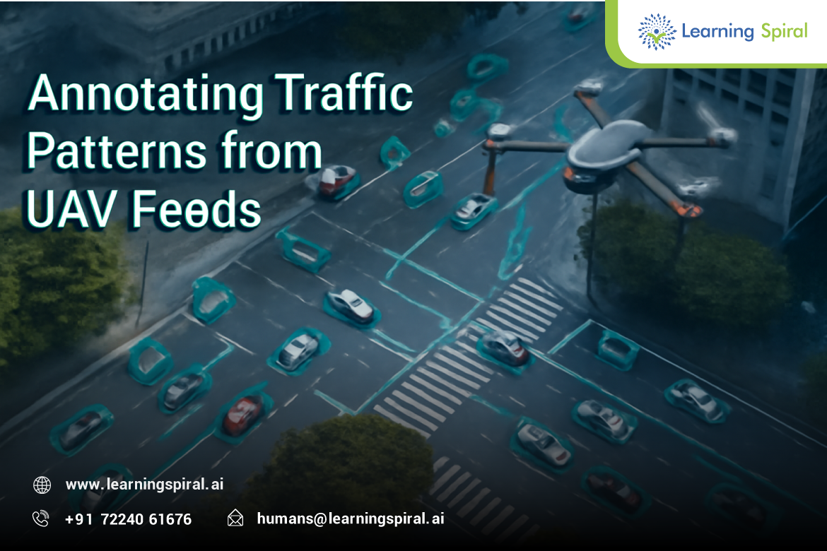
As cities grow denser and mobility demands increase, traditional traffic management approaches are no longer sufficient. Urban planners, researchers, and smart city innovators now rely on real-time aerial insights to monitor roads, intersections, and congestion levels. UAVs (Unmanned Aerial Vehicles), commonly used for aerial mapping and surveillance, have emerged as one of the most powerful tools for traffic analysis.
However, raw drone video footage alone cannot make decisions. To enable machines to interpret visual information from UAV feeds, video annotation plays a crucial role. Properly annotated UAV footage becomes the training dataset machine learning and computer vision systems use to recognize traffic patterns and make informed predictions.
🎯 Why UAV Footage Matters in Traffic Intelligence
Unlike static cameras mounted at intersections, UAVs provide:
- A wider field of view
- Dynamic camera angles
- Real-time mobility tracking across large regions
- Access to remote, high-traffic, or restricted zones
This makes drone feeds an ideal source of traffic measurement data for:
- Traffic signal optimization
- Autonomous vehicle testing
- Congestion forecasting
- Road safety audits
- Emergency route mapping
But to convert UAV footage into actionable insights, we must annotate it accurately.
🧠 Video Annotation’s Role in AI-Based Traffic Analysis
Machine learning models learn by example. With video annotation, annotators manually tag objects, events, and interactions in each frame. AI systems then learn to autonomously detect and track key elements such as:
- 🚗 Cars
- 🛵 Two-wheelers
- 🚛 Trucks
- 🚍 Buses
- 🚶 Pedestrians
- 🚦 Signal behavior
- ➡️ Lane direction & turns
Some commonly used annotation techniques include:
| Annotation Method | Purpose |
|---|---|
| Bounding Boxes | Object recognition & classification |
| Object Tracking | Follow vehicles across continuous frames |
| Instance Segmentation | Distinguish overlapping vehicles |
| Polygon Annotation | Irregular shapes like intersections |
| Temporal Annotation | Identify events like braking or waiting |
These labeled datasets form the foundation for:
- Intelligent transport systems
- Autonomous driving models
- Road safety compliance analysis
- Vehicle-to-infrastructure (V2I) systems
🚧 3D Data + Lidar Integration for Better Accuracy
When video annotation is combined with LiDAR annotation, traffic analysis becomes even more precise.
This hybrid approach enables:
- Distance measurement
- Speed estimation
- Lane violation detection
- Accident risk analysis
As a result, planners can simulate infrastructure planning, evaluate mobility efficiency, and design safer roads.
🧩 The Importance of Human-in-the-Loop Annotation
Even though automation tools are improving, they cannot detect every anomaly. Traffic dynamics change drastically based on:
- Weather & lighting
- Festival or rush hours
- Roadwork or diversions
- Geographic region
A human-in-the-loop ensures:
✔ Quality control
✔ Bias reduction
✔ Interpretation of complex edge cases
This blend of humans + automation delivers the highest AI model accuracy, especially when training critical transportation decision systems.
🏢 Why Choose Learning Spiral AI for UAV Traffic Annotation?
Learning Spiral AI is a trusted provider of high-precision data annotation services, supporting AI research, smart city development, and global computer vision companies. Our teams specialize in:
- Video annotation
- Image labeling
- LiDAR annotation
- Time-series & trajectory tagging
With scalable workforce capability and advanced QC workflows, we deliver:
- 📌 Enterprise-grade accuracy
- 📌 Secure data handling
- 📌 Fast project turnaround
- 📌 Dedicated project managers
Whether you’re building smart mobility systems, autonomous driving models, or traffic governance tools—our annotation services help ensure your AI model performs reliably in real-world conditions.
🚀 Final Thoughts
AI-powered traffic analysis is shaping the future of smart transportation. Annotating UAV footage makes it possible for systems to understand traffic dynamics at scale—leading to safer roads, reduced congestion, and more efficient mobility planning.
As cities evolve, annotated traffic data will remain a key foundation for building intelligent public infrastructure and autonomous systems.
Want to accelerate your AI project with expert annotation?
📩 Contact Learning Spiral AI to discuss requirements or request a pilot dataset.